About Japan
Japan
Japan is made up of over 3000 islands, a total landmass almost as large as the state of California. The four main islands are Honshu, the largest, followed by Hokkaido, the most northern and also the least populated, then Kyushu, the southernmost, and Shikoku. Stretching 3000km from north to south, the northernmost regions of Japan are subarctic, while the extreme south is subtropical.
Four-fifths of the land surface is mountainous and rural; most of the approximately 125 million people who live on the four main islands are packed into the coastal plains. This has led to the development of so-called ‘urban corridors’, the longest of which, and perhaps the most densely inhabited in the world, is the Tokaido belt between Tokyo and Osaka.
Apart from Hokkaido all the main islands in Japan are divided into prefectures 県 (ken); there are 47 in all. However, Tokyo is known as Tokyo-to (metropolitan prefecture), and both Osaka and Kyoto as -fu (urban prefectures) ie Osaka-fu and Kyoto-fu.
The list below includes
- the kanji for the prefecture
- the abbreviation used in Japan by Rail for the general area: CH (Central Honshu), Kan (Kansai), WH (Western Honshu), Toh (Tohoku), Hok (Hokkaido), Kyu (Kyushu), Shi (Shikoku)
- the region the prefecture is part of
- where relevant the prefecture’s capital city (‘Pref cap’).
Aichi-ken 愛知県 (CH – Chubu; pref cap Nagoya)
Akita-ken 秋田県 (Toh; pref cap Akita)
Aomori-ken 青森県 (Toh; pref cap Aomori)
Chiba-ken 千葉県 (CH – Kanto; pref cap Narita Town)
Ehime-ken 愛媛県 (Shi; pref cap Matsuyama)
Fukui-ken 福井県 (WH – Chubu; pref cap Fukui city)
Fukuoka-ken 福岡県 (Kyu; pref cap Fukuoka/Hakata city)
Fukushima-ken 福島県 (Toh; pref cap Fukushima city)
Gifu-ken 岐阜県 (CH – Chubu; pref cap Gifu city)
Gunma-ken 群馬県 (CH – Kanto; pref cap Maebashi)
Hiroshima-ken 広島県 (WH – Chugoku; pref cap Hiroshima city)
Hokkaido 北海道 (pref cap Sapporo)
Hyogo-ken 兵庫県 (Kan – Kinki; pref cap Kobe)
Ibaraki-ken 茨城県 (CH – Kanto; pref cap Mito)
Ishikawa-ken 石川県 (WH – Chubu; pref cap Kanazawa)
Iwate-ken 岩手県 (Toh; pref cap Morioka)
Kagawa-ken 香川県 (Shi; pref cap Takamatsu)
Kagoshima-ken 鹿児島県 (Kyu; pref cap Kagoshima city)
Kanagawa-ken 神奈川県 (CH – Kanto; pref cap Yokohama)
Kochi-ken 高知県 (Shi; pref cap Kochi city)
Kumamoto-ken 熊本県 (Kyu; pref cap Kumamoto city)
Kyoto-fu 京都府 (Kan – Kinki; officially Kyoto, like Osaka, is an urban prefecture)
Mie-ken 三重県 (Kan – Kinki; pref cap Tsu)
Miyagi-ken 宮城県 (Toh; pref cap Sendai)
Miyazaki-ken 宮崎県 (Kyu; pref cap Miyazaki city)
Nagano-ken 長野県 (CH – Chubu; pref cap Nagano city)
Nagasaki-ken 長崎県 (Kyu; pref cap Nagasaki city)
Nara-ken 奈良県 (Kan – Kinki; pref cap Nara city)
Niigata-ken 新潟県 (Toh – Chubu; pref cap Niigata city)
Oita-ken 大分県 (Kyu; pref cap Oita city)
Okayama-ken 岡山県 (WH – Chugoku; pref cap Okayama city)
Osaka-fu 大阪府 (Osa – Kinki; officially Osaka, like Kyoto, is an urban prefecture)
Saga-ken 佐賀県 (Kyu; pref cap Saga city)
Saitama-ken 埼玉県 (CH – Kanto; pref cap Saitama city)
Shiga-ken 滋賀県 (Kan – Kinki; pref cap Otsu)
Shimane-ken 島根県 (WH – Chugoku; pref cap Matsue)
Shizuoka-ken 静岡県 (CH – Chubu; pref cap Shizuoka city)
Tochigi-ken 栃木県 (Toh – Kanto; pref cap Utsunomiya)
Tokushima-ken 徳島県 (Shi; pref cap Tokushima city)
Tokyo-to 東京都 (Tyo – Kanto; Tokyo is thought of as a city but officially is a metropolitan prefecture)
Tottori-ken 鳥取県 (WH – Chugoku; pref cap Tottori city)
Toyama-ken 富山県 (WH – Chubu; pref cap Toyama city)
Wakayama-ken 和歌山県 (Kan – Kinki; pref cap Wakayama city)
Yamagata-ken 山形県 (Toh; pref cap Yamagata city)
Yamaguchi-ken 山口県 (WH – Chugoku; pref cap Yamaguchi city)
Yamanashi-ken 山梨県 (Toh – Chubu; pref cap Kofu)
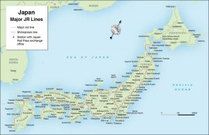
This map of Japan will give you an idea of the main rail routes. Click on the map to see a larger image.